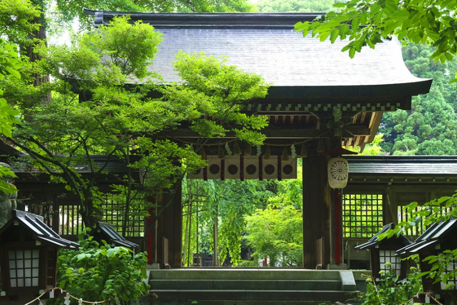
Byobuiwa Crags

Byobuiwa Crags

The Byobuiwa Crags (屏風岩) are a rock formation in Minamiaizu, in the Southern area of Fukushima Prefecture. The rocks have eroded through many years to their current shape. The crags are light in color, offering an interesting contrast with the blue of the gushing Ina river, and the vibrant colors of the surrounding foliage, creating a scenery that becomes particularly poignant during the autumn. Visitors can stroll the walking course around the crags, which takes approximately 20 minutes to be completed and includes several interesting picture spots.

Venue Details

Venue Details
Websitehttps://www.kanko-aizu.com/miru/25053/
Contact

Minamiaizu Tourism & Local Products Association
(+81) 241-62-3000

Best SeasonAll Year
Related infoBest season: May to November

Autumn foliage viewing season: Mid-October to early November (varies each year)
Access Details
AccessHirasawa area, Omomo, Minamiaizu Town, Fukushima Pref. 967-0515
View directions
Getting there

By train and bus: 1 hour by local bus No. 40 ‘Oze-Numayama Pass’ from the Aizukogen Ozeguchi Station (Tobu Revaty Aizu/ Aizu Tetsudo).

By car: Approx. 4 hours from Tokyo on the Tohoku Expressway and the National Road No. 400. Approx. 2 hours 35 minutes from Koriyama Station via National Road No. 118.

Useful Links

Oze National Park

Hinoemata Kabuki

Maezawa L-shaped Farmhouses

Nearby

The World Glassware Hall
History & Culture

Isasumi Shrine

Isasumi Shrine's history is thought to be connected to how the Aizu region got its name - a story that has been recorded in two of Japan’s most legendary books of folklore. According to the tale, around 2000 years ago, four shogun were entrusted with uniting the four areas of land which would become Japan. Two of these shogun happened to be father and son. One was sent to the northeast, and the other to the northwest.When the father and son had completed their work uniting the towns in their respective areas, they met in the middle. They named the area “Aizu” (会津), which can be translated as “The riverbank (津) where we met (会)”. The father and son travelled to Mt. Mikagura-dake, a mountain that borders Niigata Prefecture and Aizu, and prayed to the Shinto god of pioneering new lands to protect Aizu, and the rest of Japan. Isasumi Shrine is thought to be built where they met.In spring, the shrine grounds become decorated with the blossoms of one of the most prized cherry trees in Aizu. It is said that this tree, which is named Usuzumi Sakura (“Diluted-Ink Sakura”), has been the sacred tree of Isasumi Shrine since it was brought down from Mt. Mikagura-dake and planted in the shrine grounds as a way of commemorating the efforts of the father and son. The lovely, light scent of the cherry blossom welcomes visitors each spring.Aizu Misato Town’s historic Isasumi Shrine, known as a great spot for viewing beautiful irises, holds a festival to celebrate the splendor of these flowers every year.

The World Glassware Hall
Gourmet & Shopping

Yamatogawa Sake Brewery

Close to Kitakata station is Yamatogawa Brewery. This brewery was built in 1790 in the Edo Era, and has been producing sake ever since. The famous sake cultivated at this brewery is made using the clear, mountain water from Mt Iide.Another important component of Yamatogawa Brewery’s sake is the use of high-quality, carefully cultivated rice. This rice is grown in Yamatogawa Brewery’s own rice fields, and from the fields of selected local farming families. Next door to the brewery is the Northern Museum – where old earthen storehouses built during the Edo Era have been opened up to the public. Here you can learn about how the sake-making process has changed since the Edo period. Tours and sake tasting available for free.

The World Glassware Hall
History & Culture

Maezawa L-shaped Farmhouses

The deep snows of the Aizu region meant that, in the past, cut off from other areas for months at a time, its residents had to use all their wits just to make it through the winters. These L-shaped farmhouses known as "magariya" conceal a number of the innovations developed by this local people.As you can see in the layout of the house, the long earth floor stretches out towards the road. Long ago, horses were indispensable in farming, but the deep snow of winter meant that keeping them tied up in external stables was cruel. Therefore, stables were built into the house, meaning that the unfloored working area inevitably became larger. Having this area far from the road made getting to the road through the snow more difficult, as up to a meter can fall overnight. Accordingly, with the aim of reducing work, locating this working area as close as feasible to the road ended up with the house being laid out in an L-shape.Many of these houses were built in Maezawa and throughout Tateiwa Village, as a way of living with horses in the deep snows of the Aizu region.The houses have become more and more comfortable over time, with the "magariya" design lasting until the present day. While this magariya-style farmhouse used to be built everywhere that saw heavy snow, they are gradually disappearing. Accordingly, the Maezawa magariya have been designated as historical cultural assets.In 1985, the village began actively preserving these houses, and this area now attracts many visitors. One of the magariya buildings have been repurposed into a museum in the village where visitors can learn about life in Maezawa.

You might also like

Goshiki-numa Ponds
Nature & Scenery

Goshiki-numa Ponds

The Goshiki-numa ponds of Urabandai are a cluster of five volcanic lakes at the foot of Mt. Bandai. When Mt. Bandai erupted in 1888, Goshiki-numa - which translates as "Five-Colored Ponds - were formed.In actuality dozens of lakes were created due to the 1888 eruption, but the Goshiki-numa Ponds are the most famous. It was thanks to the eruption that the lakes each took on rich color; the various minerals found in each lake give them a unique color and create a mystical aura.The colors of the Goshiki-numa Ponds also change throughout the year depending on weather and time of day, a truly mysterious phenomenon. The lakes have become a popular tourist destination. The five main lakes are Bishamon, Aka, Ao, Benten, and Midoro, and their colors range from a lime green to deep turquoise to a topaz blue. A scenic walking route guides visitors around the ponds. At 3.6 km in length, this walking route - which will take you past many of the ethereal colors - takes about 70 minutes to complete.If you’d like a view of all five lakes at once, why not take the 4 km walking trail from Bishamon-numa (largest of the five lakes) up to nearby Lake Hibara. Alternatively, if hiking is not on your itinerary, enjoy a simple rowboat out on Bishamon-numa. It’s especially lovely in autumn as the color of the autumn leaves reflects on the deep green surface of the lake. In winter, there are even snowshoe trekking tours offered. The color of the lakes looks particularly vivid in winter, seeing as the minerals in some of the lakes stop them from freezing over, meaning you can see their colors contrasted with the white of the snow.Be sure to stop by the Urabandai Visitor Center, which is a large and well-equipped facility. You can find great information here about tours as well as the various geography, wildlife, and even the history of the area. It’s a great chance to learn more about the ecosystem that makes up the Goshiki-numa Ponds.

Mt. Bandai
Nature & Scenery

Mt. Bandai

Originally known as Iwahashi-yama, literally a rock ladder to the sky, the renamed Mt. Bandai is no less impressive. Often referred to as 'Aizu's Mt. Fuji', Mt. Bandai is one of the 100 most famous mountains in Japan, and has even been selected as one of the top 100 geographic landmarks in Japan. In 2011, the mountain was certified as a geopark, which is a unified area with geological heritage and international significance, as defined by UNESCO. There are seven climbing routes for Mt. Bandai, with the trail starting at the Happodai trailhead being the most popular, and easiest route. From the Happodai trailhead, the 3.5 km route takes around 2 hours to reach the summit.The various routes range from 2 to 4 hours and from 3 to 7 km. At Koubou Shimizu, one of the mountain stops, there are two shops where trekkers can buy drinks, snacks, and souvenirs, but please note that there is no accommodation available. For many Buddhist mountain fanatics, Mt. Bandai holds a place of great significance. Enichi-ji Temple, located on the southwestern foot of Mt. Bandai, is a popular temple to visit nearby. The mountains situated around the temple make for a serene vista where one can feel the power of nature. Enichi-ji Temple was founded one year after Mt. Bandai erupted, in 807 C.E.; in the past, some superstitious people believed there was a connection between the eruption and the temple’s founding... Interestingly, Mt. Bandai used to be shaped more like the famous Mt. Fuji, but after a volcanic eruption in 1888, the shape changed to what we see today. It is thanks to that eruption that the mountain gained its rugged, sharp look and the Urabandai area behind Mt. Bandai was created. For non-hikers, the Bandaisan Gold Line is a popular sightseeing road that leads up the southwestern side and offers brilliant vistas of the foliage, especially in autumn when the colors change.

Ozegahara Marsh
Nature & Scenery

Ozegahara Marsh

Ozegahara Marsh is a high-altitude marshland located in Oze National Park. This 8 square kilometer marshland is a popular hiking destination and is home to some rare plants, including white skunk cabbage, Nikko Kisuge, and Watasuge (a variant of cottongrass). Hiking trails at Ozegahara are well-maintained and used almost year-round for hikers, except in winter when the park is often closed due to snow. Being just 150 kilometers from Tokyo makes Ozegahara and the rest of Oze National Park a popular getaway from city life. Some people will even drive up early in the morning, hike the day away, and then return to Tokyo the same day. It’s admittedly a tough trip if you choose to do it all in one day. Instead, why not stay the night in one of the overnight lodgings and huts within the park grounds? There's also the option of staying at a minshuku (private homes that provide meals and lodging for tourists) in Hinoemata Onsen town. However you choose to travel to Ozegahara, you won’t be disappointed. The marshland has hundreds of small pools that are a beauty to admire. Two mountains, Shibutsusan and Mt. Hiuchigatake, almost seem to stand guard over those who admire the lovely marshland scenery. The most popular trail to hike is the Hatomachitoge, as it is only a one-hour walk from the western end of the marshland. Visit in late May to early June to enjoy the famous white skunk cabbages as they bloom across Ozegahara. In July and August, the marshlands are painted a gentle yellow by the Nikko Kisuge flowers. And in September and October, the autumn colors bathe the marshland in bright gold and crimson.

Bandaisan Gold Line
Nature & Scenery

Bandaisan Gold Line

The Bandaisan Gold Line road connects Bandai Kogen, a highland rich with lakes diverse in shapes and size, and various alpine plants, and the Aizu area, which has an immensely rich and fascinating history. This submontane sightseeing road offers diverse views of Mt. Bandai (known in Japanese as 'Bandai-san') and can lead visitors to either the mountain's rugged caldera or to the picturesque Lake Inawashiro. Visitors can discover new hidden gems every time they explore the Gold Line by car, making it a very popular spot to return to among tourists and locals. The area surrounding the road is known as a foliage-viewing spot with hairpin curves that carve through the woodlands. On the walking trail that leads to Baya-ike, a "phantom" waterfall, visitors can take in the beauty of the landscape as they hike. The most highly recommended walking course extends from Happodai to the Oguninuma wetlands, where in late June, visitors are greeted by ban array of beautiful, broad dwarf day-lilies.

Top